
St. Ignatius Airport
1 mile NE of St. Ignatius, MT · FAA Identifier: 52S · Elevation: 3006 ft MSL
Airport Overview
St. Ignatius Airport (52S)
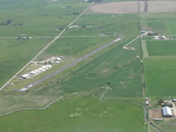
St. Ignatius Airport (52S) is a public-use general aviation airport located one mile northeast of the town of St. Ignatius in the southern Mission Valley. Open since August 1950, it sits at the foot of the spectacular Mission Mountain Range.
The airport offers pilots sweeping views of the Mission Mountains to the east and the broad Mission Valley below. Glacier National Park lies less than 100 miles to the north, making St. Ignatius an excellent staging point for mountain aviation adventures.
The town of St. Ignatius is home to the historic St. Ignatius Mission, one of the oldest churches in Montana, making the area a popular destination for both pilots and tourists.
Quick Facts
- FAA Identifier
- 52S
- Location
- 1 mile NE of St. Ignatius, MT 59865
- Coordinates
- 47-19.495833N
114-04.839817W - Elevation
- 3006 ft MSL
- Activated
- August 1950
- Status
- Open to public
Runway
- Designation
- RWY 8/26
- Length
- 2610 ft
- Width
- 60 ft
- Surface
- Asphalt
- Edge Lights
- Low Intensity
Fuel & Services
- 100LL Fuel Available
- 24-hour credit card self-service
- Minor airframe service
- Minor powerplant service
- Snow removal
- Courtesy car available
- Tiedown parking
- Pilots lounge next to fuel farm
Hangars & Contact
Information on hangar rentals and ground leases at St. Ignatius Airport may be obtained from the airport manager.
Communications & Lighting
Radio & Weather
Frequencies
- CTAF
- 122.9
Weather (AWOS)
- AWOS III at 7S0
- 119.925
- Phone
- (406) 262-3825
- Distance
- 15 nm N at Ronan
Lighting
- Beacon
- White-green, dusk–dawn
- Runway Lights
- LIRL (low intensity)
- Activation
- Key CTAF 122.9 (5×)
- Wind Indicator
- Yes
- Segmented Circle
- No
Runway Details
RWY 08/26 — Full Data
2,610 × 60 ft · Asphalt, good condition · Low Intensity Edge Lights · Single wheel load: 17,000 lbs · Traffic pattern: Left (both ends)
- Markings
- Basic, fair condition (nonstandard)
- RWY 08 lights
- 80 ft unlighted at threshold
- RWY 26 lights
- 70 ft unlighted at threshold
- Lighted portion
- 2,277 ft at night
- Overrun RWY 26
- 300 ft gravel/grass
- Terrain RWY 08
- 40 ft uphill rise on runway
Obstructions & Hazards
- Watson Road and airport fence line — 50 ft from east end of runway
- Windsock, south side of runway — in transitional surface area
- Hangars, north side of runway — in transitional surface area
- 200 ft AGL lighted cell tower — ½ mile south of airport
Airport Operations
ATC, FSS & Notices
ATC & Services
- Control Tower
- None
- ARTCC
- Salt Lake City Center
- FSS
- Great Falls Flight Service
- NOTAMs
- GTF (NOTAM-D available)
- Sectional Chart
- Great Falls
- Attendance
- Unattended
- Magnetic Variation
- 18° East
- Field Phone
- (406) 745-4008
Notices & Remarks
- ▲Migratory flocks of birds in vicinity of runway
- ▲Caution: seagulls on airfield
- ▲Snow removal available
- ●Pilots lounge located next to fuel farm
- ●Airport courtesy car — sign out in pilots lounge
- ●24-hr credit card 100LL self-service fuel
Navigation
Radio Navigation Aids
| Type | Name / ID | Frequency | Bearing / Dist | Var |
|---|---|---|---|---|
| VOR/DME | Missoula (MSO) | 112.80 | R-343 / 25.0 nm | 17°E |
| NDB | Konna (INE) | 521 | 026° / 18.9 nm | 17°E |
Based Aircraft
Aircraft & Operations
- Total Based Aircraft
- 12
- Single Engine
- 10
- Multi Engine
- 2
- Avg. Weekly Operations
- 20
- Transient GA
- 33%
- Local GA
- 65%
- Air Taxi
- 2%
- Military
- <1%
Instrument Procedures
IFR Approaches
No published instrument approach procedures at 52S. VFR only recommended for unfamiliar pilots.
Always consult current FAA charts for flight planning.
Planning Documents
St. Ignatius Airport – Master Plan
Airport Layout Plan (ALP) for St. Ignatius Airport (52S).
Questions About Our Airports?
For hangar rentals and ground leases, contact the individual airport managers. Board meetings are open to the public and held monthly.