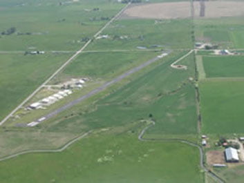
52S
St. Ignatius Airport
St. Ignatius, Montana, USA
Airport Location
| FAA Identifier: | 52S |
| Lat/Long: | 47-19-29.7500N / 114-04-50.3890W |
| 47-19.495833N / 114-04.839817W | |
| 47.3249306 / -114.0806636 | |
| (estimated) | |
| Elevation: | 3006 ft. / 916.2 m (surveyed) |
| Variation: | 18E (1985) |
| From city: | 1 mile NE of ST IGNATIUS, MT |
| Time zone: | UTC -7 (UTC -6 during Daylight Saving Time) |
| Zip code: | 59865 |
Airport Operations
| Airport use: | Open to the public |
| Activation date: | 08/1950 |
| Sectional chart: | GREAT FALLS |
| Control tower: | No |
| ARTCC: | SALT LAKE CITY CENTER |
| FSS: | GREAT FALLS FLIGHT SERVICE STATION |
| NOTAMs facility: | GTF (NOTAM-D service available) |
| Attendance: | UNATNDD |
| Wind indicator: | Yes |
| Segmented circle: | No |
| Lights: | DUSK-DAWN |
| ACTVT LIRL RWY 08/26 Key (5) times 122.9. | |
| Beacon: | White-green (lighted land airport) |
Airport Services
| Fuel Available: 24 HR. CREDIT CARD | 100LL |
| Parking: | Tiedowns |
| Airframe service: | MINOR |
| Powerplant service: | MINOR |
| Bottled oxygen: | NONE |
| Bulk oxygen: | NONE |
Runway Information
| Runway 8 / 26 | |
| Dimensions: | 2610 x 60 ft. / 796 x 18 m |
| Surface: | asphalt, in good condition |
| Single wheel: | 17.0 |
| Runway edge lights: | Low Intensity |
| RY 08 80 FT UNLIGHTED; RY 26 70 FT UNLIGHTED; 2277 FT LIGHTED AT NIGHT. | |
| Runway edge markings: | MARKINGS NONSTD |
| Runway 8 / 26 | |
| Traffic pattern: | Left |
| Markings: | Basic, in fair condition |
| Obstructions | Watson Road and airport fence line 50 ft. from east end of runway |
| WINDSOCK, SOUTH SIDE OF RUNWAY AND HANGARS, NORTH SIDE OF RUNWAY IN TRANSITIONAL SURFACES | |
Instrument Procedures
There are no published instrument procedures at 52S.
Other Nearby Airports with Instrument Procedures:
- 7S0: Ronan Airport (15 nm N)
- 8S1: Polson Airport (23 nm N)
- KMSO: Missoula International Airport (25 nm S)
- 32S: Stevensville Airport (48nm S)
- KGPI: Glacier Park International Airport (60 nm N)
Current Date & Time
| Zulu | 2026-02-22T00:22:23Z |
|---|---|
| Local | 2026-02-21T17:22:23Z |
Fuel Prices
| Type | 100LL | Jet A + Prist |
|---|---|---|
| Self Service | 5.01 | N/A |
Airport Ownership & Management
| Owner | St. Ignatius (Publicly-owned) City Hall St. Ignatius, MT 59865 Phone: (406) 745-3791 |
| Manager | Rick Newman 35333 Airport Road Saint Ignatius, MT. 59865 Phone: (406) 745-4008 Phone: (406) 544-8004 Mike Kuefler Phone: (406) 544-2274 |
Aerial Photo

Google Map
Sectional Chart
Enroute Charts at SkyVector.com
Airport Operational Statistics
| Aircraft based on the field: | 12 |
| Single engine airplanes: | 10 |
| Multi engine airplanes: | 2 |
| Aircraft operations: | Avg. 20/week* |
| Transient general aviation | 33% |
| Local general aviation | 65% |
| Air taxi | 2% |
| Military | <1% Military |
Airport Communications
| CTAF: | 122.9 |
| WX AWOS III / AV at 7S0 (15 nm N): | 119.925 (406-262-3825) http://k7s0.awosnet.com/ |
| Nearby radio navigation aids: | |
| VOR radial/distance: | MSOr343/25.0 |
| VOR name: | MISSOULA VOR/DME |
| Frequency: | 112.80 |
| Var: | 17E |
| NDB name: | KONNA |
| Hdg/Dist: | 026/18.9 |
| Frequency: | 521 |
| Var: | 17E |
| ID: | INE .. -. . |
Additional Remarks
- SNOW REMOVAL
- TELEPHONE ON FIELD 406-745-4008
- MIGRATORY FLOCKS OF BIRDS INVOF RY.
- CAUTION SEAGULLS ON AIRFIELD
- PILOTS LOUNGE LOCATED NEXT TO FUEL FARM
- AIRPORT COURTESY CAR, SIGN OUT IN PILOTS LOUNGE
- 24 HR CREDIT CARD 100LL FUEL, SELF SERVICE
- 300 FT OVERRUN ON THE END OF RY 26, GRAVEL/GRASS
- 40 FT UPHILL RISE ON RY 08
- 200 FT. AGL CELL TOWER LIGHTED 1/2 MILE SOUTH OF AIRPORT
