
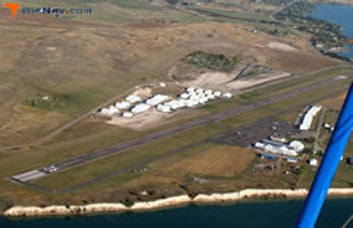
Polson Airport
1 mile W of Polson, MT · FAA Identifier: 8S1 · Elevation: 2941 ft MSL
Airport Overview
Polson Airport (8S1)
Polson Airport (8S1) is a public-use general aviation airport located one mile west of the city of Polson, Montana on the southern shore of Flathead Lake — the largest natural freshwater lake west of the Mississippi River.
The airport has been open to the public since April 1940 and is operated under the Lake County Joint Airport Board. Fuel (100LL and JET A) is available via 24-hour self-service, and major airframe and powerplant services are offered.
Polson and Flathead Lake offer exceptional summer recreation including watercraft rentals, fishing, camping, hiking, and world-class lodging. It is an ideal fly-in destination for pilots exploring northwest Montana.
Quick Facts
- FAA Identifier
- 8S1
- Location
- 1 mile W of Polson, MT 59860
- Coordinates
- 47-41.726667N
114-11.116667W - Elevation
- 2941 ft MSL
- Activated
- April 1940
- Status
- Open to public
Runway
- Designation
- RWY 18/36
- Length
- 4195 ft
- Width
- 75 ft
- Surface
- Asphalt
Fuel & Services
- 100LL Fuel Available
- JET A Fuel Available
- 24-hour self-service
- Major airframe service
- Powerplant service
Hangars & Ground Leases
Information on hangar rentals and ground leases at Polson Airport may be obtained from the airport manager directly.
Contact for InfoCommunications & Lighting
Radio & Weather
Frequencies
- CTAF / UNICOM
- 122.8
Weather (AWOS)
- AWOS III at 7S0
- 119.925
- Phone
- (406) 676-2967
- Distance
- 8 nm SE at Ronan
Lighting
- Beacon
- White-green, dusk–dawn
- Runway Lights
- MIRL, dusk–dawn
- Activation
- Key CTAF 122.8
- Wind Indicator
- Lighted
- Segmented Circle
- Yes
Runway Details
RWY 18/36 — Per-End Data
4,195 × 75 ft · Asphalt, good condition · Medium Intensity Edge Lights · Single wheel load: 17,000 lbs
Runway 18 (South)
- Heading
- 182° Magnetic / 199° True
- Threshold Elevation
- 2,937.4 ft
- Gradient
- 0.1%
- Traffic Pattern
- Left
- PAPI
- 4-light, left side, 3.00°
- Markings
- Basic, good condition
- Obstructions
- 17 ft highway, 537 ft from threshold (19:1 slope to clear)
Runway 36 (North)
- Heading
- 002° Magnetic / 019° True
- Threshold Elevation
- 2,939.2 ft
- Gradient
- 0.1%
- Traffic Pattern
- Left
- PAPI
- 2-light, left side, 4.00°
- Markings
- Basic, good condition
- Obstructions
- 10 ft ditch 168 ft from end; terrain drops 60 ft right of centerline
RWY 3W/21W — Water Runway (Flathead Lake)
Seaplane landing area also used by boats. When landing RWY 36, be alert to seaplane landings on adjacent river.
Airport Operations
ATC, FSS & Notices
ATC & Services
- Control Tower
- None
- ARTCC
- Salt Lake City Center
- FSS
- Great Falls Flight Service
- NOTAMs
- GTF (NOTAM-D available)
- Sectional Chart
- Great Falls
- Attendance
- 0800–1700
- Magnetic Variation
- 17° East
Notices & Remarks
- ▲Tower 600 ft AGL, 3 mi south — unlighted
- ▲Ridge +405 ft, 8,500 ft from RWY 36 end
- ●When landing RWY 36 — be alert to seaplane landings on adjacent river
- ●Seaplane landing area also used by boats
Navigation
Radio Navigation Aids
| Type | Name / ID | Frequency | Bearing / Dist | Var |
|---|---|---|---|---|
| VOR/DME | Kalispell (FCA) | 113.20 | R-163 / 31.1 nm | 18°E |
| NDB | Smith Lake (SAK) | 515 | 141° / 27.1 nm | 15°E |
| NDB | Konna (INE) | 521 | 356° / 37.1 nm | 17°E |
Based Aircraft
Aircraft & Operations
- Total Based Aircraft
- 56
- Single Engine
- 50
- Multi Engine
- 3
- Jet
- 1
- Helicopter
- 1
- Glider
- 1
- Avg. Daily Operations
- 27
- Transient GA
- 51%
- Local GA
- 46%
- Air Taxi
- 2%
- Military
- <1%
Instrument Procedures
IFR Approaches
-
RNAV (GPS) RWY 18
Published approach
-
RNAV (GPS) RWY 36
Published approach
-
ANGIL ONE (RNAV) Obstacle DP
Departure procedure
-
Special T/O Minimums
Non-standard departure minimums apply
Always consult current FAA charts for flight planning. Procedures subject to change.
Planning Documents
Polson Airport – Master Plan
Airport Layout Plans (ALP) and planning documents for Polson Airport (8S1).
For full master plan documents including ALP sheets, visit the Master Plan page.
View Master Plan DocumentsQuestions About Our Airports?
For hangar rentals and ground leases, contact the individual airport managers. Board meetings are open to the public and held monthly.